You are at - Jotaro's Blog / AhPek Biker / Cycling Philippines Batanes / Day 3-1 : Itbayat Torongan Caves | Jump to Day 1 / 2-1 / 2-2 / 3-2 / 4 / 5-1 / 5-2 / 6 / 7-1.1 / 7-1.2 / 7-2 / 8
AhPek Biker - Riding Adventures
Cycling Philippines Batanes Day 3-1 : Itbayat Torongan Caves
Batanes Islands - Day 3 : 16th March 2015
Route : Santa Rosa>Torongan Caves>Yauran Native Village>Lake Kavaywan>Itbayat Airport>Valance Port>Pangaraman Port>Santa Rosa.
We decided not to take our bicycles along and went on a motor-tour of Itbayat. In the morning we explored the central area of the island before heading for the south after lunch.
 |
| Our faluwa approaching Itbayat Island. |
a motor-cycle & motor-tricycle tour of Itbayat (Santa Rosa>Torongan Caves>Yauran Native Village>Lake Kavaywan>Itbayat Airport>Valance Port>Pangaraman Port>Santa Rosa.)
Distance: Boat Trip- approx 45km.; Itbayat Motor Tour- 17.36km.
Time : Boat Trip - 6:10am to 9:00am; Itbayat Tour - 9:30am to 5:35pm
Time Taken : Boat Trip - 2hrs. 50mins; Itbayat Tour - 8hra 5mins. (including hikes to Torongan Caves, visiting native village & ports).
Route Recommendations :
1. The boat trip from Batan to Itbayat takes about three to hours on a calm sea. During rough seas it could take more than that. There is a daily boat between the islands, but the schedule boat trip may be cancelled if whether is bad/stormy. The fare one way is 450PHP
2. The boats (called Faluwas) does not provide much seating and be prepared to sit/lie on the floor mats provided.
3. Take sea-sick tablets if one is prone to sea-sickness.
4. Itbayat Island is the largest of the Batanes islands, the island is very hilly. We did not cycle here but I have included a route map for those keen to cycle there. Much of the roads are gravel or laterite tracks, so be prepared with suitable tires.
5. Points of interest that should not be missed includes:
- Torongan Caves (GPS: 20.74597, 121.85513) (some hiking required).
- Yauran Native Village( GPS: 20.75582, 121.83019), see life of the original natives of the Philippines.
Time Taken : Boat Trip - 2hrs. 50mins; Itbayat Tour - 8hra 5mins. (including hikes to Torongan Caves, visiting native village & ports).
This is page 4 of a 13-page blog, Click Here To Go To Title Page.
Route Recommendations :
1. The boat trip from Batan to Itbayat takes about three to hours on a calm sea. During rough seas it could take more than that. There is a daily boat between the islands, but the schedule boat trip may be cancelled if whether is bad/stormy. The fare one way is 450PHP
2. The boats (called Faluwas) does not provide much seating and be prepared to sit/lie on the floor mats provided.
3. Take sea-sick tablets if one is prone to sea-sickness.
4. Itbayat Island is the largest of the Batanes islands, the island is very hilly. We did not cycle here but I have included a route map for those keen to cycle there. Much of the roads are gravel or laterite tracks, so be prepared with suitable tires.
5. Points of interest that should not be missed includes:
- Torongan Caves (GPS: 20.74597, 121.85513) (some hiking required).
- Yauran Native Village( GPS: 20.75582, 121.83019), see life of the original natives of the Philippines.
- seaports (view the steep ramp access and the sunsets).
- Chinapoliran Seaport (GPS: 20.78026, 121.8202).
- Valanga Seaport (GPS: 20.77011, 121.81654).
- Paganaman Port (GPS: 20.79250, 121.82920).
- Kavaywan Lake (GPS: 20.7151, 121.80838).
- Mount Karoboboan View Deck (GPS: 20.81333, 121.8553).
-- Itbayat has the most remnants of Spanish culture & architecture and has many old Spanish era stone houses with thatch roof for which Batanes is renown for.
- stopping to interact with the locals, they are really warm and helpful.
6. We stayed at Cano’s Lodge (GPS: 20.78387, 121.83832), where we had our meals too. Electricity supply for the Itbayat island is cut from midnight to 6:00am.
__________________________________________________________________________________PRELUDE
 |
| Goofy at Basco Lighthouse. |
The previous day we had cycled around Basco and northern Batan Island; it was a good introduction to the life, culture and the beautiful sights of the Batanes. Today there will be no cycling as we will be taking a 3-hour boat journey to the northern-most inhabited island of the Philippines, Itbayat. This island is the largest of the Batanes islands, and one with the most remnants of the Spanish culture and buildings.
___________________________________________________________________________________
THE RIDE
Route : Santa Rosa>Torongan Caves>Yauran Native Village>Lake Kavaywan>Itbayat Airport>Valance Port>Pangaraman Port>Santa Rosa.
We decided not to take our bicycles along and went on a motor-tour of Itbayat. In the morning we explored the central area of the island before heading for the south after lunch.
(Click here to view route map)
BOAT JOURNEY FROM BATAN TO ITBAYAT
 We woke up early, and by 5:00am started the short walk down to the Port of Basco; we had a 6:00am boat to catch and would not want to miss it! When we arrived at the port, it was still dark but after a while the sun started peeping out and in dawn's early light we saw the boats docked at the port. It was still too early and the ticketing office was not opened yet, but we are hopeful of making the trip as the weather was relatively calm (during bad weather the boat trips could be cancelled).
 As it got brighter we were able to see even more - a derelict boat moored at the piers, was it damaged by the typhoons that occasionally hit these islands around August every year?
 Our boat (locally called faluwas) arrived and all are impatient to board...
 ... but first cargo, including this motor-tricycle, are loaded. We patiently waited.
At the rear is the faluwa, the Ocean Spirit, which leaves at 8:00am. The cost each way is 450PHP.
 After all cargo has been loaded, we boarded. There is no gang-plank, and with the help of the boat hands with skipped over. Our faluwa embarks quite on time.
The boat is at least a fifty footer, with two decks. The upper deck is where the where the pilot is, behind which is a small deck which can stand about five to six. There are hardly any seating and mats are laid on the floor for most to lie down on.
Did we take our sea-sick pills? It didn't really matter, for today's sea was relatively calm and soon the rocking motion of the boat lulls us to sleep just like this baby.
 The boat is full and the poor boat-hands (about nine of them) have to sit outside. But they are prepared for this and are well covered up against the shining sun. They keep themselves occupied by throwing a line into the sea; as we neared our destination, they reel in the line.... but the it came out empty!
 Land Ahoy!
As we approached Itbayat, I am awed by the island. As we skirted the island, I noticed that the whole island literally sits on cliffs without a single beach, there don't seem to be any towns near the seaside. I later learnt that Itbayat is one of the largest uplifted coral islands in the world.
Instead we see a landing wharf at sea level with a steep ramp leading up to Itbayat (Chinapoliran) Port terminal area.
 As we make land, there was a flurry of activity up front.
The boat hands threw the heavy anchor overboard to slow down the boat's approach; the old tires were put out onto the approaching side to cushion the boat as it hit's the wharf. From the wharf side, a couple of other hands caught a thick rope thrown from the boat and tied it to the strong moors.
With the boat secured, passengers with the help of the boat hands made their way out and with a skip disembarked on the solid wharf.
 On landing we climbed up steep steps to the vehicles terminal area which was easily a hundred feet above the wharf. At top we looked down at passenger now boarding the boat for it's return trip to Batan Island. Thank goodness we did not bring our bikes, carrying them up those steep steps would have been a task!
 Now wonder vehicles do not go down to the wharf area; the ramp leading down is very steep, of almost 45 degrees incline. Goods are taken down to the wharf level by this carts held to a cable which is slowly let down by a winch at the top. A porter guides the cart so that it does not go astray and tumble into the sea!
Up at the top, there seems to be a bit of a mixed up. We were suppose to be guided by an English speaking guide but instead he had delegated us to Jason who does not speak English that well. We negotiated with him for a while but it was to no avail, we were stuck with Jason. At the end of our stay in Itbayat, we must say that Jason did perform admirably, taking good care of us albeit the minor language barrier.
In our haggling, most of the motorcycles which transport passengers to town had been taken up. So instead of three motorcycles, one for each of us, we ended up with two. Siew Yung and me shared one while Ong rode pillion with Jason. I have rode in multi-passengers motorcycles before, like the motor-dops of Cambodia which sometimes can squeeze up to four passengers. But unlike the motor-dops, the motorcycles here does not have extended seats. So there we were squeezing onto the bike and sharing the narrow foot pedal. Luckily the road to town was a good one and not bumpy, but I still held on for dear life!
 We were dropped off at Cano's Lodge where Nanay Cano was waiting for us eagerly. She welcomed us most warm heartedly, like a mother welcoming her children home.
Nanay was a former tourist information officer of the island and is thus very knowledgeable about the place. Over coffee she gave us a detailed talk on the history & geography of Batanes in general and Itbayat in particular.
Here we are like students in a class, listening attentively. Every once in a while she slipped into her native Ivatan tongue' although we could not understand Ivatan, we politely refrained from interrupting her he artful presentation.
(Note: the coffee is not on the house and comes from a neighbouring caterer. Itbayat's economy is mainly fishing based and some farming of its renown garlic and onions. Nanay is trying to improve the lot of her neighbours by spreading the tourist dollars around, so we paid up happily).
 After the talk, we popped over to the neighbouring caterer to have breakfast and were surprised by the menu; they served quite a heavy meal which included rice and a few dishes! My guess is that the Itbayatans have a hearty breakfast before starting their laborious day.
After that we had to go over at the provincial administrative office to register and pay a nominal visitors fee, this applied for all the islands we visited. We are ready to start our tour; while SY rode pillion with Jason, Ong and me shared this orange motor-tricycle. We had seen these at Batan but had not rode in one as we were cycling around back then, so this is a first for us. The roofs over the motor-cycle and cabs are rather low.
The route to the Torongan Caves was mainly over laterite and gravel roads which were very bumpy, we had to crouch town a bit to avoid our heads hitting onto the low roofs.
 Our motorcycle ride ended but we are not at the caves yet. The caves are still two kilometres away. With no direct road access, we had to hike the rest of the way through narrow and sometimes steep paths. Looks like I will have to change my name from AhPek Biker to AhPek Hiker for the meantime.
 So near yet so far....
Our hike ended but now we had to climb down some steep cliffs to reach this narrow pathway that leads to the entrance of the caves. The rocks here are young limestones, almost coral-like with rough and sharp edges, so we climbed very carefully.
 The cavern of the Torongan Caves are huge, we seemed like tiny ants, slowly crawling over the coral rocks with the ceiling hanging high over us.
 At the far end of the cave, an opening gives a nice view of the sea.
 Satisfied... and it's time to climb back up again.... have to be careful of those sharp rocks though!
 Jason took us on a different route out from the caves. It was a gentler route, one that took us through turfed slopes few trees...
 It was a worthwhile climb as at the top a rewarding vista of the island awaited us. Far away the sharp crest of Dinem Island can be seen.
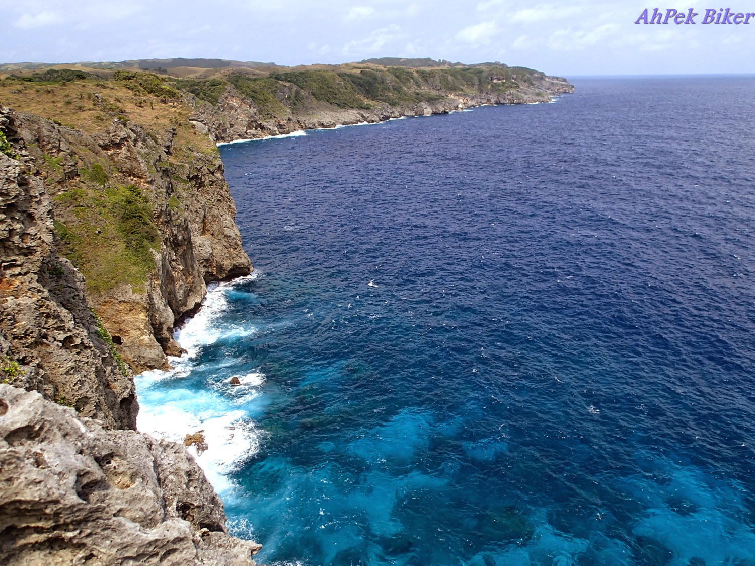 At another point we looked down below, the sea is so beautiful crashing onto the cliffs in a splendour of blue. The Torongan Caves are on a small inlet to the left.
 Wow.... WOW!
The sea is so, so blue. I am almost tempted to jump in.
Whoa..... steady there!
 Up above is a small plateau with a pathway lined by small white stones. I was wondering what was the significance of this when Jason explained that those brownish stone cairns around us are actually burial grounds of ancient aborigines who dwelt here, probably having migrated over from Formosa.
Ok.... noted.... better stay on the path lest we trod someone's grave and disturb their spirits.
VAMOOSE.... AGAIN!
 The trek back was through grassy shady paths; one much, much easier than the steep route that we took coming down. It was a longer road but we did not complain and yet wondered why we did not use this path down instead. Perhaps it's all part of the tour, to show the different faces of Torongan.
 Having trekked for close to three hours, we noticed some coconut trees and remarked that some coconut water would rejuvenate us. Quite immediately Jason climbed one of those trees and cut down some coconuts, with his parang he cut opened them for us. He's turning out to be a better guide than expected.
 It's way past noon now, sitting there sipping our coconuts direct from the nuts was one badly needed replenishment coupled with a well deserved rest.
Arriving back at the road, we hopped onto the motor-bikes and headed back to Cano's Lodge for lunch...
SEE YOU ALL IN PART TWO AFTER LUNCH!
To see more photos for the day, Click here.
___________________________________________________________________________________
___________________________________________________________________________________


At the rear is the faluwa, the Ocean Spirit, which leaves at 8:00am. The cost each way is 450PHP.

The boat is at least a fifty footer, with two decks. The upper deck is where the where the pilot is, behind which is a small deck which can stand about five to six. There are hardly any seating and mats are laid on the floor for most to lie down on.
Did we take our sea-sick pills? It didn't really matter, for today's sea was relatively calm and soon the rocking motion of the boat lulls us to sleep just like this baby.


As we approached Itbayat, I am awed by the island. As we skirted the island, I noticed that the whole island literally sits on cliffs without a single beach, there don't seem to be any towns near the seaside. I later learnt that Itbayat is one of the largest uplifted coral islands in the world.
Instead we see a landing wharf at sea level with a steep ramp leading up to Itbayat (Chinapoliran) Port terminal area.

The boat hands threw the heavy anchor overboard to slow down the boat's approach; the old tires were put out onto the approaching side to cushion the boat as it hit's the wharf. From the wharf side, a couple of other hands caught a thick rope thrown from the boat and tied it to the strong moors.
With the boat secured, passengers with the help of the boat hands made their way out and with a skip disembarked on the solid wharf.


 |
| (Photo by Siew Yung) |
In our haggling, most of the motorcycles which transport passengers to town had been taken up. So instead of three motorcycles, one for each of us, we ended up with two. Siew Yung and me shared one while Ong rode pillion with Jason. I have rode in multi-passengers motorcycles before, like the motor-dops of Cambodia which sometimes can squeeze up to four passengers. But unlike the motor-dops, the motorcycles here does not have extended seats. So there we were squeezing onto the bike and sharing the narrow foot pedal. Luckily the road to town was a good one and not bumpy, but I still held on for dear life!
___________________________________________________________________________________
THE TORONGAN CAVES

Nanay was a former tourist information officer of the island and is thus very knowledgeable about the place. Over coffee she gave us a detailed talk on the history & geography of Batanes in general and Itbayat in particular.
Here we are like students in a class, listening attentively. Every once in a while she slipped into her native Ivatan tongue' although we could not understand Ivatan, we politely refrained from interrupting her he artful presentation.
(Note: the coffee is not on the house and comes from a neighbouring caterer. Itbayat's economy is mainly fishing based and some farming of its renown garlic and onions. Nanay is trying to improve the lot of her neighbours by spreading the tourist dollars around, so we paid up happily).

After that we had to go over at the provincial administrative office to register and pay a nominal visitors fee, this applied for all the islands we visited. We are ready to start our tour; while SY rode pillion with Jason, Ong and me shared this orange motor-tricycle. We had seen these at Batan but had not rode in one as we were cycling around back then, so this is a first for us. The roofs over the motor-cycle and cabs are rather low.
 |
| Click on video to see a You Tube video of bumpy ride to the Torongan caves. |


Our hike ended but now we had to climb down some steep cliffs to reach this narrow pathway that leads to the entrance of the caves. The rocks here are young limestones, almost coral-like with rough and sharp edges, so we climbed very carefully.


The sea is so, so blue. I am almost tempted to jump in.
Whoa..... steady there!

Ok.... noted.... better stay on the path lest we trod someone's grave and disturb their spirits.
VAMOOSE.... AGAIN!


Arriving back at the road, we hopped onto the motor-bikes and headed back to Cano's Lodge for lunch...
SEE YOU ALL IN PART TWO AFTER LUNCH!
This is page 4 of a 13-page blog, Click Here To Go To Title Page.
To see more photos for the day, Click here.
___________________________________________________________________________________
Related Blogs :
 |
 |
 |
 |
 |
___________________________________________________________________________________
You May Also Like : |


 |
 |
 |
 |
 |
 |
 |
You are at - Jotaro's Blog / AhPek Biker / Cycling Philippines Batanes / Day 3-1 : Itbayat Torongan Caves | Jump to Day 1 / 2-1 / 2-2 / 3-2 / 4 / 5-1 / 5-2 / 6 / 7-1.1 / 7-1.2 / 7-2 / 8
If you like this, view my other blogs at Jotaro's Blog
(comments most welcomed below. if you like this pls share via facebook or twitter)
No comments:
Post a Comment